Imagine the day when no one complains about traffic disruption caused by transportation infrastructure rehabilitation work being performed (almost everywhere 24/7), and when the United States is known as the best country in the world for getting where motorists want to go safely and efficiently. The i2dEAS LAB will make this vision real by working to improve public safety and mobility across cities and beyond, while also satisfying the burning needs of decision-makers and the general public. The research program described below shows the greatest promise for achieving both aims.
i2dEAS LAB has sought to achieve these aims by creating, experimenting, exploiting, and implementing new fundamental concepts and groundbreaking models through a multi-disciplinary view to promote intellectual cross-pollination with fields outside the lab's areas of expertise. We create new science and foster advances in emerging areas related to transportation infrastructure informatics.
i2dEAS LAB strategically aims at addressing the unique spectrum of challenges and issues facing state transportation agencies, daily commuters, and business enterprises in heavily congested metropolitan areas. The following are the brief descriptions of each of the five (5) specific Strategic Research Areas (SRA).
SRA1: Machine-Learning Experimentation to Predicting the Level of Mobility Disruption
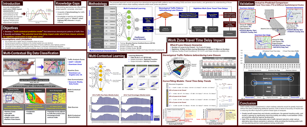
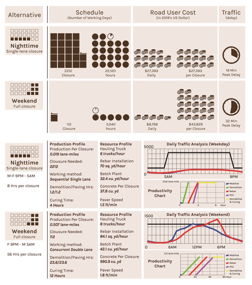
The overarching goal of this project is to greatly improve mobility and safety in and around highway construction work zones (CWZs) by creating and testing a focused cyber-physical decision-support system. This system would predict potential work zone impact on motorists, affected communities, and businesses. To achieve this goal, this research investigates an integrative high-fidelity computing concept that blends novel deep-learning traffic pattern prediction algorithms based on inputs from existing sensors located on roadway segments in an urban corridor with CWZ impact assessment techniques. We propose a decision-support model: Spatiotemporal Work Zone Assessment for Transportation Management Plans (SWAT). Utilizing deep-learning methods, SWAT will automatically recognize how stereotypical regional traffic patterns react to existing CWZs and implemented transportation management plan (TMP) strategies, based on roadway characteristics as well as socioeconomic inputs. Then, SWAT will automatically generalize its understanding of those reactions to other roadway networks where work zones are planned. In this way, CWZ impact assessment in urban roadway networks would be greatly improved, both in terms of accuracy of results and in reducing the effort required to perform these types of analyses: the image below summarizes the outcomes of a study, specifically aimed at developing an AI predictive model to determine the mobility impact of various nighttime lane closure scenarios on an urban highway network in Southern California.
SRA2: Autonomous Accident Risk Prediction through Simulations and AI (Collaborator: KAIST Transmatics Lab led by Dr. Yeo)
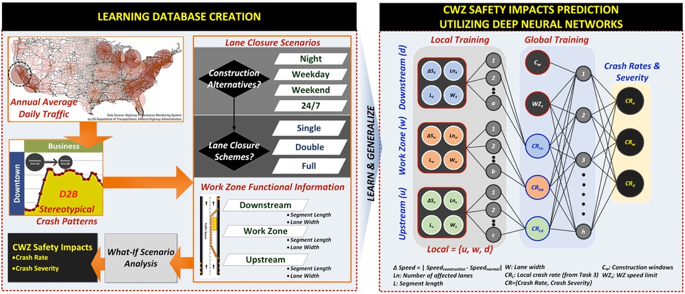
Using sensor-based big data in transportation planning has become increasingly common, yet a critical knowledge gap concerning the data’s precision persists. Even in a common spatial region, large variations exist in data collected before and during construction, due to the lack of spatial correlation between neighboring sensors within a road section. Furthermore, a new federal rule requires all state transportation agencies to implement work zone safety impact assessments. These impact assessments are critical, but they are also difficult and expensive to produce, with the primary problem being a lack of standardized methods. No methods or tools mirror the unique spatiotemporal dynamic characteristics of work zones, and the typical methods are often project-specific, frequency-driven, time-consuming, costly, and error-prone. This project fills these two knowledge gaps by providing a novel big data imputation method and ultimately, by creating a data-driven decision-support model and testing its reliability for predicting accident risks. The major objective of this project is therefore to create a big-data-based computer model and test its reliability for predicting accident risks caused by the presence of a work zone under arbitrary lane closure strategies. This will be achieved by conducting a five-stage method that articulates a new spatiotemporal data imputation technique and modeling frameworks where the level of safety disruption is assessed and the model’s prediction accuracy, fused from a machine-learning algorithm, is validated.
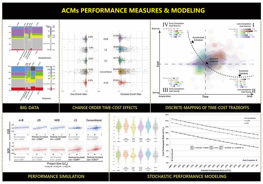
SRA3: Alternative Contracting Methods: Holistic Analysis Approach
- How to balance access, mobility, and livability in planning, constructing, and executing multimodal transportation systems in urban corridors.
- Data-driven investigation on the performance effects of various alternative contracting methods (ACMs) such as DB, CM/GC, A+B, I/D, No Excuse Bonus, Lane Rental, etc,
- Stochastic modeling, discrete-event simulations, and advanced statistical analyses aiming at (1) investigating the marginal impact of various ACMs on key performance measures while controlling for different project and market characteristics and (2) developing decision-support computer applications for the improved ACMs. The root problem this study addresses is how to determine when and what type of delivery method to use in order to realize the maximum benefits with regard to project type, size, and complexity.
- Providing historical data-driven performance benchmarking results for ACMs that state transportation agencies can reference when evaluating competing contracting methods and techniques for high-impact highway rehab projects.
SRA4: Cost-Schedule-Traffic-Productivity-Risk Integrated Tradeoff Analysis for Effective Decision-Making
- Interdependence analysis of schedule-cost-change-productivity-risk-quality associated with critical highway rehabilitation projects.
- Advanced statistical analyses including a non-linear regression analysis built in a set of clusters with the goal of (1) analyzing the macroeconomic performance of the construction industry as a whole and at fourteen of its sub-sectors in terms of labor productivity, gross margin, and worker’s wages and (2) developing a quantitative model that predicts a firm’s profitability by analyzing various levels of labor productivity and taking crucial external factors into account.
- Schedule/cost/traffic integrated tradeoff analysis to devise the most feasible and economical scenarios for high-impact urban highway rehab projects: helping TxDOT choose the most realistic contract times and transportation management plans, resulting in immediate, tangible monetary savings in road user costs and agency costs.
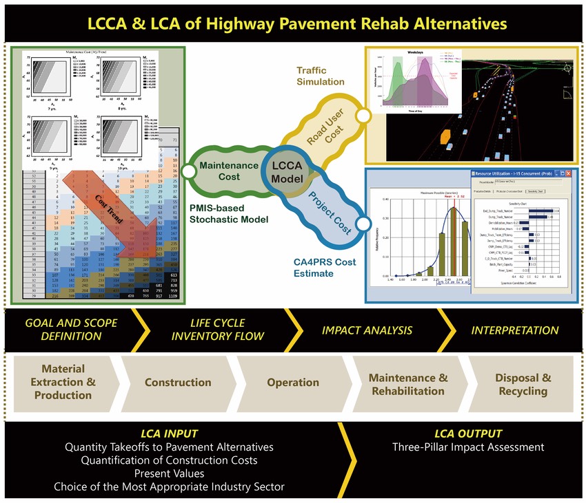
SRA5: Infrastructure Sustainability: life-cycle cost analysis (LCCA) & life-cycle assessment (LCA)
For major highway pavement rehabilitation projects, a federal rule enforces the agencies to perform a Life-Cycle Cost Analysis (LCCA) that accounts for both the agency cost and the future maintenance cost. For instance, TxDOT mandates the implementation of a LCCA for significant highway pavement construction projects with greater than 30 percent trucks or 100,000 average daily traffic volumes. The following three critical problems in the current LCCA practice are observed: 1) existing methods like RealCost require too many intuitive assumptions; 2) existing methods are time-consuming; and 3) the accuracy of the analysis performed under the numerous unrealistic assumptions is highly questionable. This project aims at developing a groundbreaking decision-support computer model for quantifying the most realistic, reliable life-cycle costs that account for the total project cost, the future maintenance cost and the road user cost within a viable integration analysis framework using a series of K-means cluster-driven regression analyses based on the big data gathered through the Pavement Management Information System (PMIS). This research effort is the first of its kind, as the existing tools including RealCost require many intuitive assumptions and judgments. The proposed decision-support model has the great potential to greatly assist state transportation agencies to carry out a LCCA with the reliable estimation of the agency cost and road user cost. A more accurate life-cycle cost can help STAs make better-informed decisions when selecting the most feasible project scenarios among numerous alternatives, which can translate to better use of public funds. Estimating long-term maintenance costs and road user cost is the cornerstone of the LCCA. Therefore, methods developed from this project have great potential to improve the accuracy of LCCA.
- GIS-based urban sustainability model to assess the impact of LEED sustainable site credits.
- Economic impact analysis of LEED public transportation accessibility.
- Modeling future highway maintenance costs to support a life-cycle cost analysis for major infrastructure improvement projects.
- Economic Input-Output Life-Cycle Assessment (EIO-LCA) of highway pavement rehabilitation alternatives to assess sustainable use of energy, external costs, and toxic emissions.